
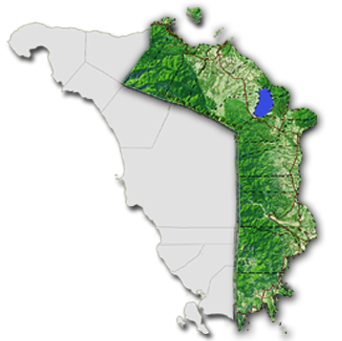
LOCATION
Oriental Mindoro is located in Region IV-B, otherwise known as the MIMAROPA Region. It lies 45 kilometers south of Batangas and 130 kilometers south of Manila.
BOUNDARY
It is bounded by Verde Island Passage on the North; Maestro del Campo Island and Tablas Strait on the East; Semirara Island on the South; and Occidental Mindoro on the West.
LAND AREA
Oriental Mindoro has a total land area of 4,364.72 square kilometers or 436,472 hectares. It represents 1.5 % of the total land area of the country and 16% of the MIMAROPA Region.
TOPOGRAPHY
Oriental Mindoro has a rugged terrain and an irregular coastline. Numerous rivers and streams traverse the province but none are navigable by large vessels.
CLIMATE
The province has two climate types: Type I and Type III. Type I is characterized by two pronounced seasons, dry and wet. Type III has no pronounced season, relatively dry from November to April and wet during the rest of the year.
CAPITAL
Calapan City
LEGAL BASIS
RA 505 (Division of Mindoro)
DATE OF APPROVAL
November 15, 1950
TWO CONGRESSIONAL DISTRICTS
14 MUNICIPALITIES
426 BARANGAYS
ONE COMPONENT CITY